Living in a toxin-free environment is essential to people’s mental and physical health. Being exposed to chemicals from pollution in soil, air, and water has wide ranging health effects including acute asthma symptoms, hormone disruption, decreased mental ability, and cancer. A U.S. national environmental quality index determined that there are over 30 more cases of cancer in counties with poor environmental quality than in counties with the least exposure to toxins in the air, water, and soil (approximately a seven percent increase).[1]
In addition to being a health issue, a toxin-free environment is also a quality-of-life issue with equity implications. Across the United States, low-income communities and communities of color are more likely to be exposed to environmental toxins. Facilities using toxic substances that can pollute the soil, air, and water are often located in low-income, non-white neighborhoods.[2] The demographics are similar for neighborhoods containing hazardous waste treatment, storage, and disposal plants.[3] Additionally, studies have shown that within cities, low-income neighborhoods are exposed to higher levels of air pollution from highways and factories, putting residents at higher risk for acute asthma attacks and other illnesses.[4]
In an Environmental Protection Agency (EPA) ranking of environmental pollution in metropolitan areas in the United States, called the Risk Screening Environmental Indicators (RSEI), the District of Columbia ranks 576 out of 2,357 localities.[5] D.C. is a dense urban environment. As such, every ward in the District has some exposure to chemicals that are released by daily activities including personal transportation, household behavior, and commercial activity. However, given the District’s RSEI ranking in the top quartile of counties, we wondered what environmental hazards exist here? Where in the city are these hazards concentrated? What does that mean for the health and health equity of District residents?
A survey of the District’s environmental hazards, their locations, and their impacts follows, examining soil contamination, air pollution, and water pollution. Overall, we have found that residents of Wards 4, 5, and 6 are disproportionately exposed to chemicals in the soil, air, and water from sources outside of daily activity.[6]
Soil contamination
In the District, as in the rest of the United States, there is contaminated land due to hazardous waste being dumped, left out, or improperly managed. Soil contamination can happen if hazardous chemicals are spilled or improperly disposed of, as well as if contaminated soil migrates to uncontaminated areas. Contamination can occur if chemicals are not stored properly, during the application of fertilizers or pesticides, and through chemical and industrial processes. People then can be exposed to chemicals by breathing in contaminated dust, touching contaminated soil, or eating food grown in contaminated soil, in turn impacting their health.
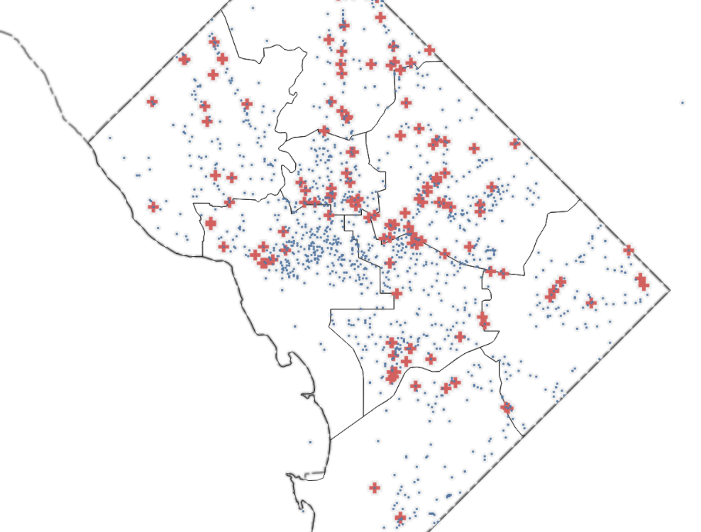
The most common element polluting soil in D.C. is leaking underground storage tanks (LUSTs). These tanks often hold petroleum and sewage, which contain bacteria and chemicals that are harmful to human health. Brownfields, or sites where future use is affected by environmental contamination, are the next most common soil contaminant contributors, and are concentrated in parts of the city where there has been significant development in recent years. More brownfields may be found in the future as more properties around the city are redeveloped. Superfund sites represent the lowest number of soil contamination sites in the District and are largely driven by dry cleaners. The majority of superfund sites are located in Wards 4 and 6.
Leaking underground storage tanks
Underground storage tanks (USTs) are tanks and underground piping connected to tanks, with at least ten percent of the container volume below ground. They can hold toxic materials including but not limited to hazardous waste, regulated substances, septic materials, wastewater, oil, and gasoline (petroleum). USTs are a potential hazard if they contain toxic chemicals that leak into the soil and groundwater. Congress began regulating USTs in 1984, creating protocols for tank installation, design, corrective action, and closure to minimize tank leaks. As of 2005, USTs are inspected every three years to identify leaks and other potential issues.[7] Since 1987, officials have identified 1847 leaking underground storage tanks (LUSTs) in the District, the majority of which have been cleaned up and had their leaks corrected.
Health effects and cleanup of LUSTs
D.C.’s underground storage tanks are regulated locally by the District Department of Energy and Environment (DOEE) Underground Storage Tank (UST) Program. DOEE has identified leaking underground storage tanks (LUSTs) and engaged in cleanup efforts to protect against adverse effects of petroleum, petroleum related products, and hazardous materials.
DOEE has established standards for chemical levels in order to protect the health and safety of District residents. The department tests soil for many chemicals found in oil, gas, and hazardous materials including total petroleum hydrocarbons (TPHs), gasoline range organics, and diesel range organics. Additionally, groundwater is tested for many chemicals including lead, benzene, and toluene.[8] The health effects of these chemicals require more study and are dependent on the amount and type (skin, air, water, etc.) of exposure.
Nonetheless, some health effects of chemical exposure are known. Lead exposure can cause damage to children’s developing nervous system resulting in IQ loss and impacts on learning, memory, behavior, and growth; kidney (renal) effects in adults; anemia; reproductive disorders; and neurological impairments. Studied health disorders related to total petroleum hydrocarbons (TPHs) include skin and eye irritation, breathing and neurologic problems, and stress. TPHs impact mental health and induce physical and physiological effects, and are potentially toxic to genetic, immune, and endocrine systems. The long-term effects of TPHs in humans are not fully understood yet and certain symptoms may persist for years after exposure.[9] TPHs and Benzene have also been linked to cancer in medical studies.[10] At present, there is not enough data to determine if Ethylbenzene and Xylenes, other chemicals found in petroleum, cause cancer.
Where leaking underground storage tanks (LUSTs) are located in the District
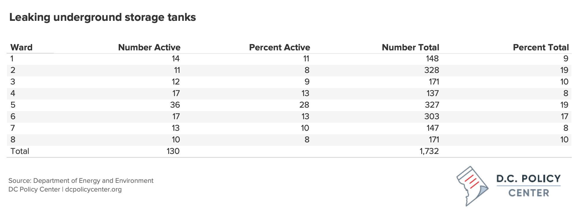
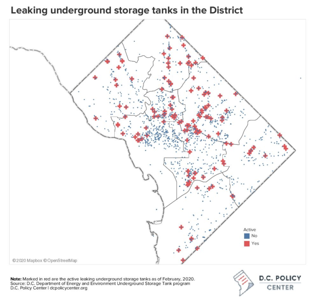
Since 1987, the District has registered 1847 leaking underground storage tanks (LUSTs). The good news is most of these sites have now been cleaned up. As of 2020, only 130 of those 1847 tanks have not completed cleanup and are still currently active, potentially damaging and contaminating nearby soil and groundwater. While LUSTs have been remediated and cleaned up in every ward in the District, a higher proportion of Ward 2 LUSTs have been cleaned up and resolved than LUSTs in other wards. While Ward 2 held 18.9 percent of leaking underground storage tanks over the last 30 years,[11] it currently accounts for 8.46 percent of active leaking sites (11/130).
Brownfields
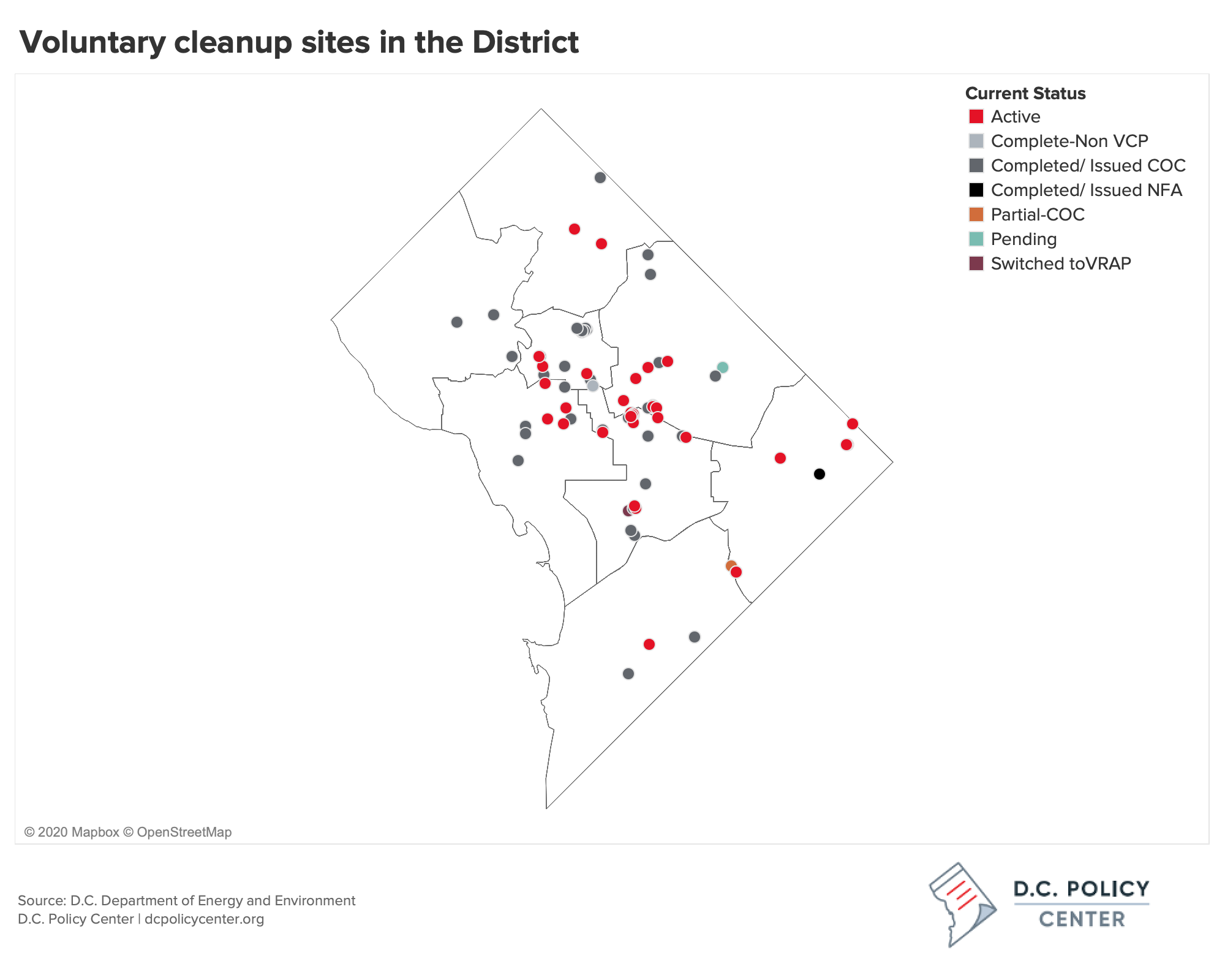
A brownfield is a property where development and reuse of land are hindered by previous contamination by hazardous substances. The District employs voluntary cleanup programs (VCP) to incentivize the cleanup of brownfields by owners or developers who did not cause the contamination. Brownfields, or sites contaminated by hazardous substances, are eligible for voluntary cleanup programs if they are not listed on the U.S. Environmental Protection Agency’s National Priority List and are not the subject of a current cleanup action by the Environmental Protection Agency or the Environmental Health Administration.
When a community has questions about a site, or a site is up for redevelopment, an environmental site assessment is conducted by DOEE to understand the environmental conditions of the property and determine if there are potential threats to the environment or human health. These assessments include reviewing records of the property, visually inspecting the site, sampling and testing the soil and groundwater, and developing plans for cleanup such that the property meets the District’s environmental standards. Because an assessment is initiated by community concern or redevelopment, known brownfields may be more highly concentrated in areas with intense development. This means additional brownfields may exist that have not yet been identified.
The majority of identified brownfields in the District, both cleaned up and active, are located in Ward 6. Of the active sites, or sites that have not yet completed cleanup, the most sites are located in Wards 6, 7, and 5, in respective order.
Superfund sites
A superfund site is another example of land with soil contamination due to hazardous and improperly managed chemicals. Superfund sites differ from brownfields in that the cleanup of superfund sites involves coordination with the EPA. Often, superfund sites are on the National Priorities List (NPL), a list of the nation’s worst hazard sites. These sites can include manufacturing facilities, military activity, dry cleaners, and landfills. Common contaminants found at superfund sites include lead, asbestos, dioxin, and radiation.[12] Health effects of these chemicals include cancer, lung disease, neurological effects, and endocrine disruption. The EPA cleans up these contaminated sites or funds local governments to do the cleanup.
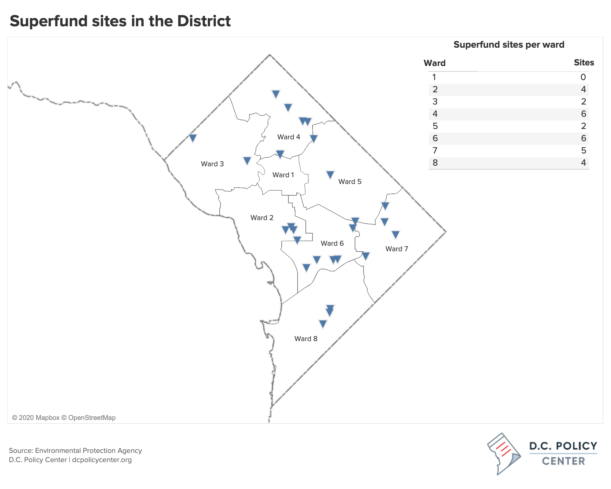
There are 29 superfund sites in D.C., and none of them are on the national priority list, which means the EPA does not include them among the nation’s most hazardous waste sites. While we do not know the chemicals released for all, we know that 9 of 20 are associated with dry cleaners, one is a gardening center, one site is associated with a mercury spill that happened at Ballou High School in 2003, one is a medical facility, one is the result of a protest march to the EPA headquarters when protestors left drums filled with contaminated water, one is a previous landfill which is now a part of the National Park System, and others have to do with previous land use (such as the munitions plant in Navy Yard).
We also know the location of the sites that the EPA is actively cleaning up. The majority of superfund sites in the District are located in Wards 4 and 6 (with six sites each), while Wards 3 and 5 have the fewest sites (two each).
Air pollution
In addition to contaminated soil, residents of the District are also exposed to air pollution: mainly ozone and particulate matter. Air pollution affects residents’ ability to breathe and can exacerbate asthma prevalence and symptoms in both children and adults. Known harmful chemicals for which levels are tested under Environmental Protection Agency (EPA) National Ambient Air Quality Standards (NAAQS) include ground-level ozone, particulate matter, nitrogen oxide, sulfur oxide, lead, and carbon monoxide.
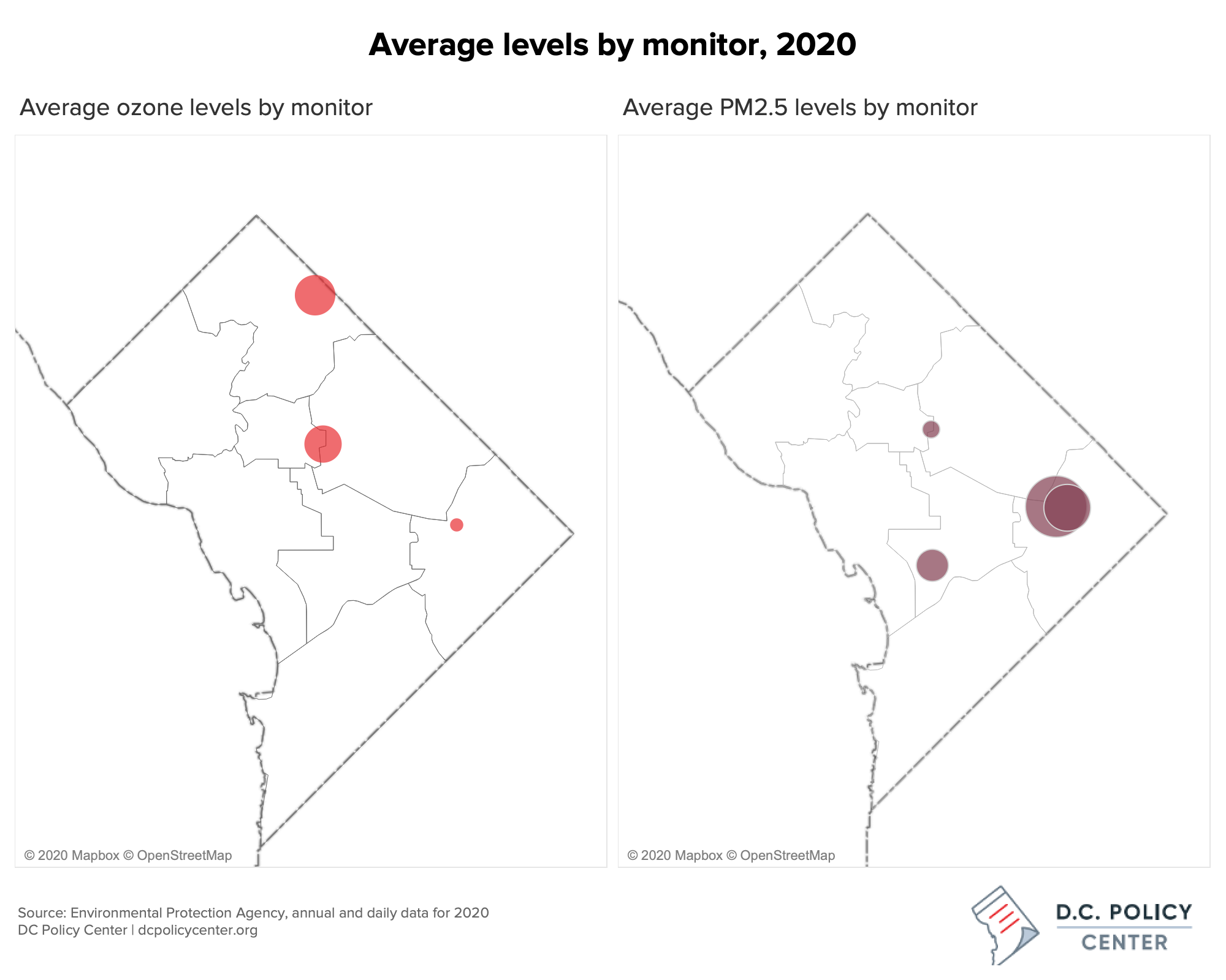
Ward 1 has the highest concentration of ozone, largely driven by vehicle exhaust. Ward 7 has the highest levels of particulate matter (known as PM 2.5).
Health impacts of chemicals in the air
Health impacts of these chemicals can include inflammation and irritation of the respiratory tract, leading to coughing and difficulty breathing, acute asthma attacks and other respiratory diseases, and aggravated heart (cardiovascular) diseases. Specifically:
- Carbon monoxide exposure can lead to visual and cognitive impairments, headaches, and nausea.
- Lead exposure can cause damage to the nervous system, IQ loss, impaired learning and memory, and more.
- Ground-level ozone can increase risk of pre-eclampsia and preterm birth during the first trimester, and particulate matter exposure has been linked to low birth weight and an increased risk of a child developing asthma later in life because particulate matter can travel into the placenta.
Air pollution has been connected to mental, neurological, and respiratory health. The Center for Disease Control’s (CDC) Behavioral Risk Factor Surveillance Survey shows that D.C.’s child and adult asthma rates of lifetime prevalence are significantly higher than the national averages.[13] When data is disaggregated by race, it is revealed that white children in the District have lifetime rates of 6.5 percent while Black children have asthma rates of 23 percent.[14] Besides having disparate rates of asthma, there are also disparate rates of acute asthma attacks in D.C., resulting in emergency room visits. While there are many causes of asthma including poverty, stress, and other health conditions, neighborhoods with higher percentages of Black residents have more air pollution than neighborhoods with majority white residents.
Air pollution monitoring sites in the District
There are five main locations where air pollution data is collected by DOEE, located at Takoma Recreation Center, McMillan Reservoir, Hains Point, River Terrace Site, and Anacostia Freeway.[15] Not every site collects the same information, but generally information is collected on ozone, particulate matter, carbon monoxide, sulfur dioxide, and nitrogen dioxide. The District stopped monitoring lead in 2016 because levels were consistently below the National Ambient Air Quality Standard (NAAQS). D.C. levels for all other pollutants have gone down over time and are currently within all NAAQS with the exception of ozone. Nonetheless, even air pollution levels within acceptable safety standards can adversely affect health.
The largest air pollution challenge in the District is ozone, for which D.C. and surrounding counties in Virginia and Maryland receive a “marginal nonattainment” designation, meaning we are within 11 parts per billion (ppb) of the standard for which air is safe for “sensitive” populations such as asthmatics, children, and the elderly. Transportation, especially exhaust from personal motor vehicles, is a leading creator of ground-level ozone.
The monitoring site at McMillan Reservoir, located near Howard University, had the highest average concentrations of ozone and sulfur dioxide in 2019. This site, in 2019, also had the most days of ozone at dangerous levels (5 days) and particulate matter (PM 2.5) at dangerous levels (2 days). Particulate matter above dangerous levels[16] was also observed at both of Ward 7’s monitoring sites for at least one day in 2019. The two sites in Ward 7, located at the Anacostia Freeway and River Terrace, both had higher averages of particulate matter, carbon dioxide, and nitrogen oxide than the other monitoring sites in the District.
COVID-19 has changed the volume of commuter traffic coming into the District, affecting the amount of air pollution. So far in 2020, there have been no days where the concentration of ozone reached dangerous levels. However, patterns have largely remained the same for differences in averages across sites from 2019 to 2020. The average levels of particulate matter and ozone for 2020 are shown below.
Heat distribution in the District
Air quality is worsened by urban heat islands, as heat and pollution can work in conjunction to make breathing challenging. As previously documented by the D.C. Policy Center, the District has uneven heat distribution, with the city center experiencing the most heat and least vegetation and neighborhoods west of Rock Creek Park having the most trees and coolest temperatures. Increased pollution in the center and east sections of the city, coupled with increased heat from the built environment, worsens air quality for residents and has the potential to trigger acute asthma attacks.[17]
Pollution in the water
Water in the District is contaminated by waste released into the Potomac and Anacostia rivers and overflow from the combined sewer and rainwater systems. Bodies of water in the District have been deemed impaired for human and aquatic life due to high levels of bacteria (E. coli), high pH, low levels of dissolved oxygen, and high turbidity (the degree to which the water loses its transparency due to the presence of suspended particulates). There are several permit holders in the District that are allowed to release waste into the water. These sources of contamination are concentrated in the Anacostia River – just as air and soil pollution are more concentrated in the southeast portion of the city than the northwest.
Sewer overflow
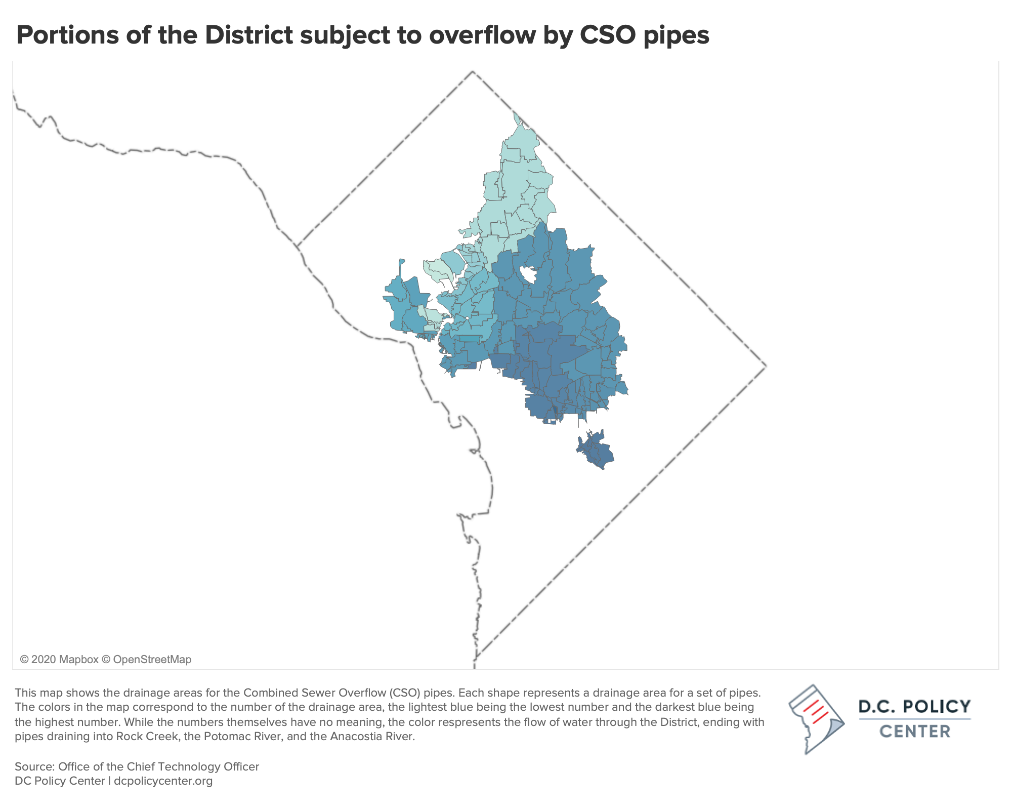
DC Water, the District’s water and sewer authority, collects wastewater in both separate and combined pipes. Combined Sewer Overflow (CSO) pipes cover about a third of D.C., draining rainwater and storm overflow into the same sewer pipes that collect liquid from toilets, tubs, and sinks. These CSOs overflow in times of heavy, prolonged rain, letting the excess flow enter directly into the District’s rivers and creeks, namely into the Anacostia River, Rock Creek Park, and Potomac River.[18]
For small amounts of rainfall, the overflow from CSOs typically lasts less than 24 hours. However, with over an inch of rain, the effects of CSOs on water quality can persist up to three days.[19] CSOs are a concern in the District as they contain harmful bacteria to people in addition to compounds, like nitrogen, that contribute to low dissolved oxygen levels in water: potentially killing fish.
Rain can thus cause violations of water standards, as fecal coliform bacteria present in sewage mixes with rainwater and flows into Rock Creek, the Potomac River, and the Anacostia River. Due to flow and location of CSOs, the southeast section of the city is exposed to the most water pollution from the sewer system, while Ward 3 is exposed to none.
Water pollution permits
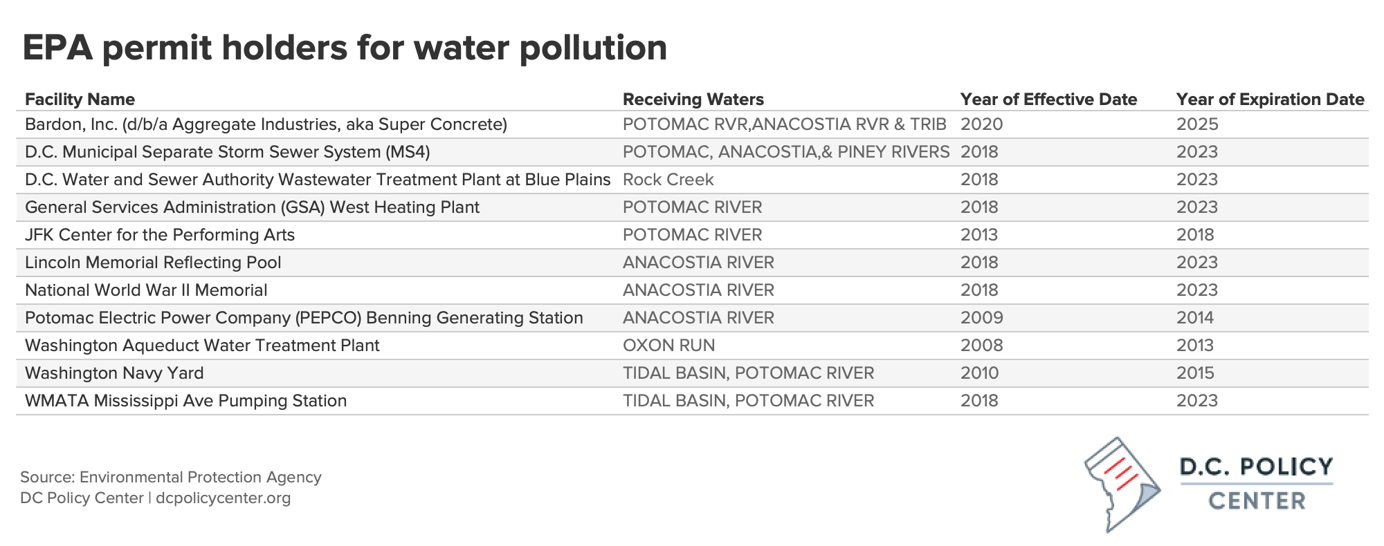
Under the Clean Water Act, people and companies are prohibited from polluting in bodies of water. However, National Pollutant Discharge Elimination System (NPDES) permits can be acquired from the EPA to discharge substances into bodies of water (pursuant to safety standards). In the District, there are currently seven companies with active permits. Pollution in the water can include substances such as radioactive material; sand; and chemical, industrial, and agricultural waste.[20]
These permit holders include:
- storm and wastewater runoff (D.C. Municipal Separate Storm Sewer System, Washington Navy Yard),
- treatment plants (D.C. Water and Sewer Authority Wastewater Treatment Plant, Washington Aqueduct Treatment Plant, WMATA Mississippi Ave Pumping Station),
- energy generation (GSA West Heating Plant, PEPCO Generating Station),
- development corporations (Bardon, Inc),
- and large event centers and public spaces (JFK Center, Lincoln Memorial, National World War II Memorial).
Of the District’s waterways, the Potomac and Anacostia rivers most frequently receive pollution from permit holders in the District (3 current permits each). Most permit holders have been industrial (9 permits), with one permit for wastewater and one for the DC Water and Sewage Authority (Blue Plains). Most of the permits are still active, except for the JFK Center, Navy Yard, Pepco, and the Washington Aqueduct Division.
The District monitored 36 waterbody segments over a period from January 2015 to June 2019 (2020 reporting period), and found that while water quality is improving, bodies of water in the District are still “impaired for human health and aquatic life”. This impairment is largely due to high levels of bacteria (E. coli), high pH, low levels of dissolved oxygen, and high turbidity (the degree to which the water loses its transparency due to the presence of suspended particulates).
In comparison with the Potomac River, the Anacostia River has higher levels of E. coli bacteria and exceeds standards for dissolved oxygen and turbidity. In the Anacostia watershed, Kingman Lake has the highest number of samples of any in the District exceeding turbidity standards, with as many as 43.16 percent of samples not meeting the District standard.
Rock Creek tributaries exceeded turbidity standards significantly less than Anacostia tributaries, with averages of 4.23 percent and 25.37 percent of samples that did not meet standards, respectively.
Samples from the Potomac River had higher numbers of exceedances of safety standards for pH levels, although exceedances remained less than 6 percent of samples.[21]
Northeast and Southeast D.C. have the most environmental pollution in the District
Wards 4, 5, and 6 collectively have the most environmental pollution in the District in terms of soil and air exposure. In addition, heavy rains divert sewer water into the Potomac and Anacostia rivers which flow to the southeast of the city, and permit holders can potentially release toxic materials into bodies of water that flow to southeast D.C.
Soil contamination from LUSTS, brownfields, and superfund sites are concentrated in Wards 4, 5, and 6. Additionally, while air monitoring sites in Ward 7 experienced heightened levels of certain chemicals, the monitoring site at McMillian Reservoir (Ward 1) experienced the highest average levels of ground-level ozone in 2019, the only chemical for which D.C. is not within standard limits. As such, the wards in the District with the highest area median income and highest levels of white residents (Ward 3) are the least affected by environmental toxins examined in this report.
About the data
Datasets on Superfund sites, air quality monitors, and water pollution permit holders come from the Environmental Protection Agency. Datasets on leaking underground storage containers and voluntary cleanup sites come from the Department of Energy and the Environment. The shapefile containing the combined sewer overflow system comes from the Office of the Chief Technology Officer.
