The Washington, D.C. region has one of the best transit systems in the U.S. But even when it’s working perfectly, its radial layout does a poor job connecting non-downtown destinations. In a series of posts beginning today, I’ll lay out the case for better suburb-to-suburb transit.
Despite Metrorail’s recent ridership meltdown, our rail transit ridership per route mile is fourth in the country, after New York, Boston, and Chicago, and we have the second-largest fraction of commuters using transit after New York. However, like most American transit systems, it is largely made up of radial lines intended to bring workers to jobs downtown, a holdover from a time when most jobs and nearly all white-collar jobs were located in urban downtowns.
But, while downtown D.C. is still the largest single job center in the region, the vast majority of regional jobs—around 90 to 95 percent—are located outside of the downtown area. Over the last several decades, more and more office, retail, and other jobs have moved to suburban areas. Instead of living in the suburbs and working in the city, many people are increasingly commuting between different suburbs. This suburbanization of work has contributed to the national suburbanization of poverty, while also making it difficult or impossible for many workers to get to their jobs without driving.
Given that the majority of the region’s jobs and residents are found in the suburbs, more suburb-to-suburb circumferential transit service is badly needed. However, this need is commonly ignored: the Greater Washington Partnership’s recently-released transportation plan does call for transit improvements, but the only explicit suburb-to-suburb transportation expansion it calls for is new toll highway lanes that will primarily serve cars.
The Purple Line, which is expected to begin service in late 2022, will provide an important suburb-to-suburb link, and local officials should seriously consider constructing extensions to Tysons Corner and Largo. However, extending the Purple Line beyond that is unlikely to be viable because the trip from Largo to Tysons would be about two hours: roughly the maximum practical end-to-end travel time for an urban rail line. Meanwhile, a Beltway loop line is not a good solution to the region’s suburb-to-suburb transit deficiency, because it would miss important destinations while providing service to low density areas with little potential for redevelopment.
Instead, high-investment Bus Rapid Transit (BRT) or, in some cases, light rail lines should be built to connect dense residential and job clusters in the suburbs to each other and to Metrorail lines.
More capacity in the core is important, but not enough
In the long term, Metrorail needs more capacity for trains passing through the region’s core. Before ridership declined following service cuts and the rise of ride-hailing, the system was facing serious overcrowding issues, mainly due to inadequate capacity for getting commuters across the Potomac.
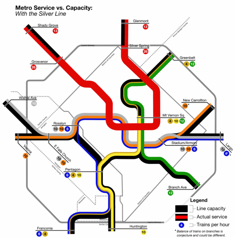
Since the opening of the Silver Line, all Orange, Silver, and Blue line trains have to share the same tracks from Rosslyn through downtown D.C. Because the capacity of these tracks is only 26 trains per hour, if they were shared equally, each line could only run a train about once every 7.5 minutes—not frequently enough for rush hour service.
Running Blue Line trains across the Yellow Line bridge to L’Enfant Plaza, as WMATA did during “Rush Plus,” doesn’t really solve the problem. Trains crossing the Yellow Line bridge over the Potomac have to then share tracks with the Green Line downtown. Sending more Yellow or Blue Line trains across the bridge reduces the number of Green Line trains that can serve the Waterfront and Navy Yard stations, which have been more heavily used since the area was redeveloped.
This map illustrates Metro’s capacity problem. It shows how trains from different lines use the capacity of each section of track, which is shown in black. Downtown, all the track capacity is full. Adding more trains to the Yellow Line bridge would mean reducing service on Green.

Image by Matt’ Johnson.
To resolve this problem, WMATA hopes to someday add a new Potomac River crossing, and more subway tunnels through downtown. A “separated Blue Line” running from Rosslyn to Stadium Armory through Georgetown and a tunnel under M Street was first suggested in the 1990s. More recent plans call for a loop consisting of a new tunnel from Rosslyn to Union Station that then turns south to connect to the Yellow Line bridge (where there is excess capacity).
Unfortunately, adding a new tunnel or two through downtown D.C. and building a new crossing of the Potomac will be expensive, and is unlikely to be completed before the 2040s. In the meantime, it’s worth looking at potential transit expansions that will serve more people without exacerbating this problem.
Further radial extensions are unlikely
Radial extensions of Metro are almost always popular in suburbs beyond the ends of Metro lines: extending the Orange Line west from Vienna and the Yellow Line south to Fort Belvoir are perennial favorites in Virginia, while extending the Red Line north to Gaithersburg and Germantown, and the Green Line to BWI, are common suggestions in Maryland. Currently, the Maryland Department of Transportation is responding to suggestions that the Green Line should be extended to Waldorf by studying a potential light rail or BRT line from Branch Avenue to Waldorf.
Radial extensions are relatively cheap to build, since they can usually be built in open trenches, along freeway medians, or on elevated berms with overpasses or underpasses for major roads. It is possible to extend Metro lines in the suburbs using freeway medians, existing rail lines, and open low-density land use few cross-streets. However, these same features also make the areas around them less walkable and less suited to transit-oriented development.
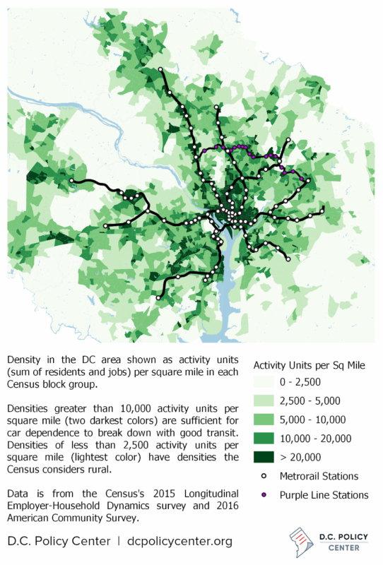
Overall regional density and Metrorail stations
Relatively short extensions to dense, walkable destinations just beyond the ends of current lines may be effective at making significantly more jobs and homes transit-accessible, but more long extensions into far-out suburban areas are unlikely in the foreseeable future.
For example, in 1997 the Blue Line was extended from Van Dorn Street to Franconia-Springfield. The extension did not lead to significant transit-oriented development or walkability at the Franconia-Springfield station, but it did make thousands of jobs in Springfield more Metro-accessible. Would a similar extension of the Orange Line to Fair Oaks (the dark green area just west of Vienna on the density map below) be worth it? Or would it only shift the crowded park-and-ride garages at Vienna a few miles further west, at great expense?

Density of jobs and residents in the D.C. region
The major problem with radial extensions of Metro is that, if they do attract new riders, they are likely to add to the problem of congestion in the core, at least once the current maintenance backlog is resolved and frequencies and hours of service return to normal. This is because these riders—and the trains to serve them—will have to pass through the existing bottlenecks at the Potomac River crossings and in downtown D.C. One reason that Virginia has put off considering an Orange Line extension is that it would only worsen the overcrowding on the Orange Line.
This latter issue is also a problem for the perennial proposals to build a Metro line under Columbia Pike in southern Arlington County. Although this would serve a dense and built-up corridor that badly needs improved transit, it would result in one more Metro line in Northern Virginia with no space to cross the Potomac into D.C.
Metro’s core capacity problem is so severe that in 2014 during his remarks at the opening ceremony for the first phase of the Silver Line, then-WMATA General Manager Richard Sarles said outright that the Silver Line would be the last Metrorail extension until core capacity is solved. Suffice it to say, adding more subway tunnel capacity downtown will be very expensive and take a very long time, if it’s possible at all.
Connecting suburban employment
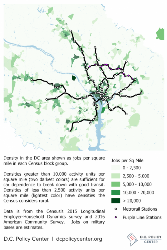
As transit consultant and DC Policy Center fellow Alon Levy recently noted, employment density can be an even more important predictor of transit ridership than residential density.
In American metro areas with a large fraction of their total jobs in dense downtown areas where it is expensive to park and where congestion makes commuting by car slow and inconvenient, significant numbers of commuters will choose to take transit to work, even if they live in less-than-walkable neighborhoods.

Density of jobs in the D.C. region
Since many suburban commuters drive to park-and-ride stations and take transit to their workplaces, transit can still serve workers who live in areas that are not transit-accessible. On the other hand, since completing the “last mile” in one’s own car isn’t possible if one’s car has been left at home or in a park-and-ride, it is particularly essential that workplaces be clustered densely around transit stops.
The Washington region, like the US’s other high-transit-ridership metro areas, has between 5 and 10 percent of the jobs in its Metropolitan Statistical Area located in the downtown core. The other 90 percent of jobs in the area are located outside of downtown, generally in lower-density areas. Some of them, like retail workers and home service providers, can’t cluster much more than the residential population.
However, many of these suburban jobs are located in large clusters, such as Tysons Corner and Bethesda, with significant density: Roughly a third of the jobs in the metropolitan area are located in clusters of at least ten thousand jobs that are dense enough to be reasonably served by transit. Making as many as possible of these jobs accessible by fast, frequent, and reliable transit should be an important component of any plan to serve the region’s transit needs.
Many of the largest suburban job clusters in the region are already near Metro stations, or will be once the Silver Line Phase II opens. Of the 19 suburban clusters with at least 20,000 jobs, only Fort Belvoir, Merrifield-Fairfax Hospital, Fair Oaks, and Montgomery Mall are not largely or entirely within walking distance of current or under-construction Metro stations.
However, while locations like Tysons Corner, White Flint, and Silver Spring are served by Metro stations, reaching them from anywhere else in the suburbs not on the same line often requires a very indirect trip through downtown. A network of circumferential transit lines, such as the Purple Line, could greatly increase the fraction of the region’s residents who can reasonably take transit to these sites.
Feeding Metrorail lines
Of course, while connecting as many jobs as possible to transit is important, it is also important to ensure that residents can, whenever possible, walk to transit from their homes. Within the District, closely spaced Metro stations combined with frequent and convenient local bus service already put most of the city within walking distance of transit that’s practical to use.
In suburban areas, though, distances are generally longer. Local buses may be enough to feed residential riders the last mile to commuter stations, but on their own they can’t connect disparate clusters to each other. BRT or light rail lines are needed to connect the region’s denser suburban clusters to Metro stations and to each other in a reasonable time. This is a task that circumferential transit lines can perform quite well, and future lines should be planned to serve as many concentrations of residents and jobs as possible.
Since most travelers using a circumferential line will not be commuting to somewhere on that same line, however, it’s particularly important that circumferential lines have good transfers to Metro, and are anchored to as many Metro lines as possible.
Maryland’s Purple Line satisfies this goal, with four Metro transfers in sixteen miles. Virginia’s planned Route 7 BRT line will, if built, connect to Metro in Tysons and at East Falls Church.
Job clusters in the Washington region with more than 10,000 jobs
| Cluster | Jobs | Area (Sq. Mi.) | Jobs / Sq. Mi. | Cluster | Jobs | Area (Sq. Mi.) | Jobs / Sq. Mi. |
|---|---|---|---|---|---|---|---|
| New Downtown* | 194,000 | 1.31 | 148,000 | Shady Grove | 22,000 | 1.47 | 15,000 |
| Old Downtown* | 186,000 | 1.73 | 108,000 | Montgomery Mall | 22,000 | 0.90 | 25,000 |
| Tysons Corner | 89,000 | 3.37 | 27,000 | Shaw / U Street | 22,000 | 0.91 | 24,000 |
| Fort Belvoir | 51,000 | 5.25 | 10,000 | Silver Spring | 21,000 | 0.52 | 41,000 |
| Reston | 37,000 | 1.93 | 20,000 | Children’s & VA Hospital | 19,000 | 0.40 | 47,000 |
| Bethesda | 37,000 | 0.54 | 68,000 | University of Maryland | 19,000 | 0.53 | 35,000 |
| Rosslyn | 35,000 | 0.44 | 78,000 | Potomac Yard | 18,000 | 0.51 | 35,000 |
| L’Enfant Plaza | 34,000 | 0.64 | 53,000 | New Carrollton | 18,000 | 1.73 | 11,000 |
| Merrifield/Fairfax Hospital | 34,000 | 2.37 | 14,000 | Mixing Bowl | 18,000 | 0.80 | 22,000 |
| Crystal City | 31,000 | 0.75 | 42,000 | Old Town Alexandria | 17,000 | 0.35 | 50,000 |
| Fair Oaks | 31,000 | 1.64 | 19,000 | Georgetown University | 17,000 | 0.19 | 89,000 |
| Ballston | 30,000 | 0.55 | 56,000 | Joint Base Anacostia-Bolling | 17,000 | 1.50 | 11,000 |
| Rockville | 29,000 | 0.65 | 44,000 | Georgetown | 15,000 | 0.22 | 70,000 |
| NoMa | 28,000 | 0.56 | 50,000 | Clarendon | 12,000 | 0.33 | 38,000 |
| White Flint | 25,000 | 1.18 | 21,000 | Friendship Heights | 11,000 | 0.38 | 30,000 |
| Medical Center | 23,000 | 1.01 | 23,000 | American University | 10,000 | 0.62 | 17,000 |
| The Pentagon | 23,000 | 0.10 | 221,000 |
* New Downtown is the downtown area west of the White House, served by Farragut, Foggy Bottom, and Dupont Circle Metro stations. Old Downtown is the downtown area east of the White House, served by Metro Center, Gallery Place, Federal Triangle, and Archives Metro stations.
In the following posts in this series, I’ll discuss options for improving the Washington region’s suburb-to-suburb transit connections, including Purple Line extensions to Largo and Tysons Corner, BRT lines in the planning stages in Montgomery County and Northern Virginia, and potential corridors that should also be considered for BRT or light rail lines.
This article is part one in a seven-part series focusing on circumferential transit in the Washington, D.C. region. Continue reading part two.
The full series includes:
1. Why the Washington region needs better suburb-to-suburb transit
2. Our region needs better suburb-to-suburb transit, but a Metro loop isn’t the best option
3. The best way to build a Purple Line link between Bethesda and Tysons Corner
4. Why it makes sense to extend the Purple Line to Largo, but not National Harbor
5. Northern Virginia needs better suburb-to-suburb transit. Here’s where rapid bus service could help.
6. Here’s where rapid bus service could best connect Maryland’s suburbs
7. For circumferential transit in the District, try crosstown bus lanes
This article also appeared at Greater Greater Washington.
